Case Lake Property is located in Steele and Case townships, 80 km east of Cochrane, NE Ontario close to the Ontario-Quebec border. The Case Lake pegmatite swarm consists of six spodumene dykes: North, Main, South, East and Northeast Dykes on the Henry Dome and the West Joe Dyke on a new tonalite dome. Case Lake has the advantage of year-round road access. The Case Lake Property is 10 km x 9.5 km in size and consists of 475 cell claims which are 100% owned by Power Metals. In June 2019, Power Metals completed its option agreement requirements with a third party and the cell claims ownership was 100% transferred to Power Metals on Ontario government’s Mining Lands Administration System (MLAS).
The Case Lake pegmatite swarm occurs along a subprovincial boundary between the metasedimentary Opatica Subprovince to the north and greenstone Abitibi Subprovince to the south. The Opatica Subprovince consists of the granitic Case Batholith, and the Abitibi Subprovince consists of the Scapa metasedimentary rocks (metagraywacke and garnet schist) and the Steele volcanic rocks (amphibolite) in the Case Lake area. The Case Batholith is an extensive 50 by 85 km ovoid granitic complex.
The lithium mineralization is hosted by spodumene in pegmatite dykes. The pegmatite dykes consist of muscovite-albite-K-feldspar-quartz-spodumene pegmatite zones with aplite border zone. The North, Main, South and West Joe Dykes are hosted by biotite tonalite laccolith offshoots from the Case Batholith. The East and Northeast Dykes are hosted by fine-grained biotite-garnet metasedimentary rocks.
Power Metals has conducted four exploration programs on the Case Lake Property:
2017 summer drill program
The 2017 summer drill program consisted of 5405.08 m and 50 drill holes. The drill holes intersected the North, Main, South and new Dykes. The drill holes had 30 m spacing along section and 30 m between sections. The hole length ranged from 60-150 m, azimuth of 150°C and dip 45°C.
The assay highlights on Main Dyke include:
The 2017 drill program extended the Main Dyke spodumene pegmatite zone 250 m to the west of the historic drill holes. Drilling has also shown the Main Dyke Zone is typically 32-35 m wide close to surface and consists of multiple spodumene pegmatite dykes at depth.
Drilling also discovered two new spodumene pegmatite dykes located between the Main Dyke and the South Dyke. The dykes have similar mineralogy to the Main Dyke with aplite border zone, spodumene granite and quartz + spodumene core zone. The first new dyke was intersected in holes PWM-17-42 and PWM-17-43 and then targeted to intersect it again in holes PWM-17-44 and PWM-17-49. This new dyke is located 20-40 m down hole from the Main Dyke and 35-40 m vertical depth from the surface. The second new spodumene pegmatite dyke was intersected in holes PWM-17-42 and PWM-17-49. It is located 50 m down hole from the Main Dyke and 50-80 m vertical depth from surface.
Assay highlights for the first new dyke include:
As a result of drilling on the Main Dyke, Power Metals identified that the Main, North, South, East, and Northeast pegmatite Dykes are not hosted by the Case Batholith as previously thought, but by a single laccolith (i.e., dome). The Case Batholith is a 50 x 85 km ovoid granitic complex characterized by a gravity low. Power Metals has identified that the Batholith has multiple laccolith domes along its margins. The domes are visible in Google Earth images as white outcrops and are topographic highs. A total of nine domes have been identified on the Case Lake Property and are exploration targets for additional pegmatites dykes.
Prospecting discovered high-grade very coarse grained spodumene mineralization at the surface at the Northeast Dyke and spodumene mineralization on the East Dyke. The mineralogy of the newly discovered spodumene mineralization on the Northeast Dyke is similar to that in the Main Dyke with spodumene chip assay results ranging from 6.04% to 7.14% Li2O. The East Dyke, which was previously thought to be barren, was discovered to contain a mineralized zone containing up to 10% fine to coarse grained spodumene ranging in size from 0.5-6cm and grading up to 2.56 % Li2O.
2018 winter drill program
The Northeast Dyke is located 900 m northeast of the Main Dyke, along the same strike as North and Main Dykes and within the same tonalite dome as North and Main Dykes. The Northeast Dyke has a pair of parallel pegmatite dykes (i.e., north and south outcrops) similar to North and Main Dykes. The Northeast Dyke is likely emplaced along the same deep-seated structure as North and Main Dykes.
Megacrysts of spodumene were discovered on the Northeast Dyke in the fall of 2017 and this discovery was followed up with a drill program in January 2018. The 2018 winter drill program consisted of 3020.0 m and 33 drill holes. The drill holes ranged in length from 44-209 m.
Assay highlights include:
2018 summer drill and mapping program
The 2018 summer drill program consisted of 4571 m and 44 drill holes. The drill holes range in length from 20 to 303 m. The drilling targets included: infill drilling on the Main Dyke, follow up drilling on the new dykes between Main and South Dykes found at the end of the 2017 drill program, East Dyke extension and discovery of West Joe Dyke.
Drill hole PWM-18-84 was a longitudinal hole designed to test the continuity of the Main Dyke along strike and down dip. The two high grade intervals for PWM-18-84 listed below are separated by a quartz core.
Assay highlights include:
Four separate spodumene pegmatite dykes were intersected in drill holes PWM-18-85, 86 and 87 in close proximity to the Main Dyke. Thus, they will add to a future resource on the Main Dyke.
Assay highlights on the new dykes include:
The new dykes between the Main and South Dykes are open along strike
In July/August 2018, Power Metals completed 10 drill holes, 987.63 m (PWM-18-100 to 109) to extend the East Dyke by 320 m westward from known outcrop. The East Dyke now has a total strike length of 1.1 km. This was the first drill hole on the East Dyke, as it was not drilled historically.
West Joe Dyke
In August 2018, Power Metals geologist discovered West Joe spodumene pegmatite, 790 m west of Little Joe Lake, 1.6 km southwest of the western edge of the Main Dyke and 3.0 km southwest of the Northeast Dyke. Two days after the discovery, spodumene was intersected in drill hole PWM-18-111 at West Joe. Power Metals drilled 18 holes, 1195.73 m (PWM-18-111 to 127) on West Joe Dyke.
Drilling on the West Joe Dyke intersected exceptionally high-grade lithium intervals:
Longitudinal drill hole PWM-18-123 intersected high-grade Lithium (Li) and Tantalum (Ta) mineralization:
These two high grade intervals were separated by 2.92 m of tonalite. This is a total of 31.34 m of high-grade Li and Ta mineralization in longitudinal drill hole PWM-18-123.
Drill hole PWM-18-124 had similar excellent results:
Also, for a total of 31.30 of high-grade Li and Ta mineralization in this longitudinal hole.
Power Metals drilled holes PWM-18-123 and 124 parallel to the West Joe Dyke to confirm the down dip continuity.
In addition to Lithium and Tantalum mineralization, West Joe Dyke also contains Cesium (Cs) mineralization as shown by the presence of pollucite in drill core and exceptionally high-grade Cs intervals:
Pollucite is rare in pegmatites in Ontario, as it has only been identified in five pegmatite localities in the province: Power Metals owned Case Lake, Tot Lake and Marko’s pegmatites and two other localities. The presence of pollucite in drill core is spatially associated with high-grade Lithium and Tantalum mineralization and should indicate very low iron contents in the spodumene.
Elevated Cs assays and pollucite has been previously identified in drill hole PWM-18-49 in the first new dyke below Main Dyke:
Elevated Cs assays has also been identified in drill hole PWM-18-71 in the Northeast Dyke:
The presence of Cesium mineralization in West Joe, Main and Northeast Dykes along the same strike suggests a common origin for these dykes and the possibility of more Li-Cs-Ta mineralization to be found.
Mapping
From May to September, 2018, Power Metals also completed a mapping program on 8 of the 9 tonalite domes in search of spodumene pegmatites similar to the Main Dyke on the Henry Dome. Exploration mapping highlights include:
Dome 9 occurs 2.7 km northeast of the Main Dyke and 1.6 km northeast of the Northwest Dyke. A beryl pegmatite 3 m wide with pale green beryl crystals 7 x 11 cm long was found in the central part of the dome. A 10 m wide pegmatite dyke with lepidolite, blocky K-feldspar and yellow muscovite was discovered near the beryl dyke. Seven other pegmatite dykes were also found on Dome 9. All of the pegmatite dykes found to date on Dome 9 have a strike similar to that of the Main Dyke in the Henry Dome.
Case Lake exploration targets
West Joe, North, Main and Northeast Dykes occur along a SW-NE trend and have the same spodumene mineralization (Figure 1). Dome 9 is on the same strike as the spodumene pegmatites (Figure 2). This entire 5.0 km long corridor is an exploration target for addition spodumene pegmatites.
Proposed drilling along this corridor would target: West Joe Dyke, between West Joe and Main Dykes, between Main and Northeast Dykes, Dome 9 and East Dyke. West Joe Dyke is a three-commodity pegmatite: Li-Cs-Ta. North, Main and Northeast Dykes are two commodity pegmatites: Li-Ta, although Main and Northeast Dykes have trace Cs mineralization which should be further explored. Once access to Dome 9 is improved with a trail, Dome 9 should be stripped to look for spodumene pegmatites.
Cesium at Case Lake
In January of 2020, Power Metals Corp. formed a Strategic Review Committee responsible for reviewing several options regarding the Company’s Case Lake Property. These options include the continuation of further drilling and development at Case Lake, a potential joint-venture with a strategic partner or the potential sale of the property. This decision came at a time when the Company began to see a lot of interest around the Cesium discovery at the West Joe Dyke.
The Company conducted stripping and channel sampling programs at the property this Spring/Summer with the purpose of exposing, sampling and assaying Cesium mineralization on surface outcrops at West Joe Dyke and to find more Cs-bearing pegmatite dykes nearby.
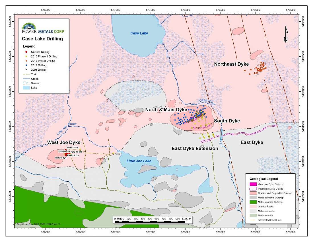
Figure 1 Case Lake Property showing the location of West Joe Dyke, Main Dyke, East and Northeast Dyke drilling.
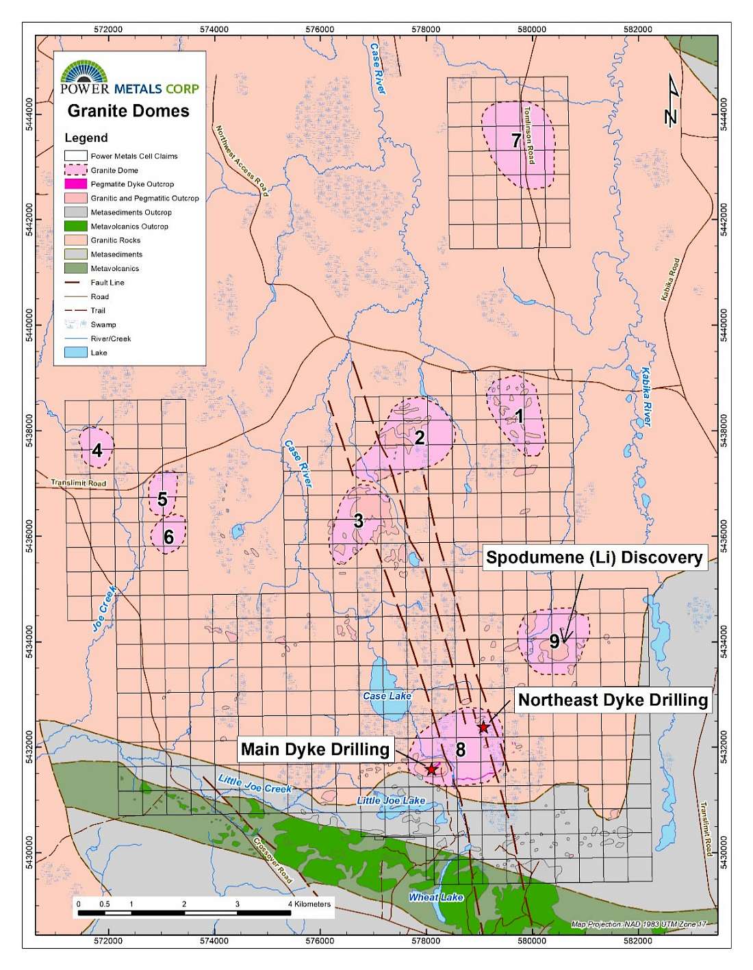
Figure 2 Case Lake geology map showing the location of 9 domes and spodumene discovery on Dome 9.
Case Lake Expansion
During the year ended November 30, 2020, the company staked an additional 107 cell claims to expand Case Lake Property, Cochrane, northeastern Ontario. The staking added 4 additional granitic domes to the Case Lake Property bringing the total to 14 domes. Each dome has the potential to host Li-Cs-Ta pegmatite dykes close to surface. The new domes are Abbotsford, Joe Creek, Kenning Lake and Circle Lake.
The highlight of the staking is the acquisition of the Abbotsford dome in Abbotsford township. The Abbotsford dome is located on the east end of the 12 km long mineralization trend from West Joe Dyke to Main Dyke to Northeast Dyke to Dome 9. The Abbotsford dome has excellent access with the Trans limit Road next to it as well as several logging trails within in it. The dome also has abundant outcrop.
The Joe Creek dome is located west of the Case Lake Property, and Kenning Lake and Circle Lake domes are located northwest of the Case Lake Property. The staking of these three domes is part of Power Metals regional exploration plan. All three domes have excellent road access which include logging trails. All three domes have abundant outcrop and are topographic highs.
The claims were staked following our exploration model first described in Power Metals press release dated Nov. 6, 2017. The Li-Cs-Ta pegmatites at Case Lake are hosted by biotite tonalite domes (laccoliths) within the Case Lake Batholith. The dome shape was confirmed by the 2017 drill program. Main, North, East, South and Northeast spodumene pegmatite dykes are exposed on surface and are hosted by the Henry Dome (also known as Dome 8). The West Joe Li-Cs-Ta pegmatite dyke is exposed on surface and is hosted by a new dome (Dome 10). Case Lake Property had 9 identified domes plus the new dome for West Joe. The new staking adds 4 more granitic domes to the Case Lake Property. Each of the newly staked domes have the potential to host Li-Cs-Ta pegmatites.
Power Metals discovered West Joe spodumene pegmatite dyke at the end of the 2018 drill program. Power Metals built a drill trail to access claims on the west side of Little Joe Lake which lead to the discovery. There has been no historic exploration around West Joe Dyke. Power Metals drilled 18 drill holes for a total of 1195.7 m on West Joe Dyke. Cesium ore mineral, pollucite, was intersected in six drill holes at a vertical depth of 5 to 40 m. While the high-grade Lithium and Tantalum (Li and Ta) mineralization at West Joe were obvious to the geologists in the field, the grade of the Cs mineralization was not realized until assays were received after the drill program was completed. Power Metals were drilling West Joe to target Li mineralization and now want to change the focus to the Cs mineralization. Power Metals is fortunate that all three commodities (LiCs-Ta) occur in the same pegmatite dyke.
An additional 8 cell claims were staked to connect the Crossover Road to West Joe Dyke. These claims will give Power Metals the ability to build a shorter access trail about 1.8 km long to West Joe Dyke as opposed to the current 4.5 km long access trail from the Crossover Road. An additional 13 claims were staked to connect the Case Lake Property to Dome 7 on Tomlinson Road for land management.
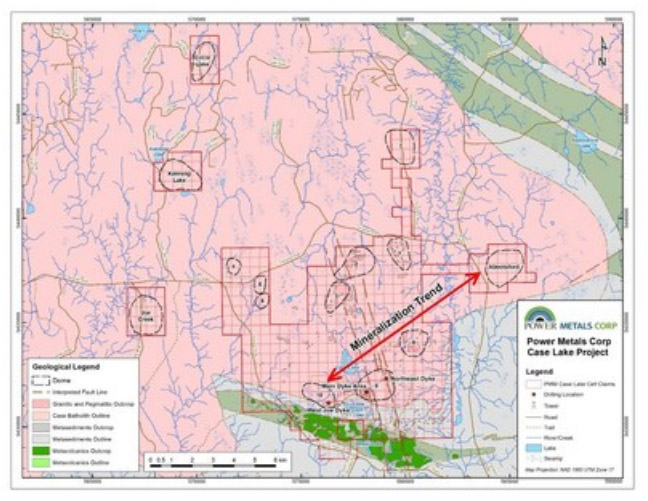
Figure 3 Geology map of Case Lake showing the location of granitic domes.
West Joe Dyke contains Cesium (Cs) mineralization as shown by the presence of pollucite in drill core and exceptionally high-grade Cs intervals:
Elevated Cs assays and pollucite has been previously identified in drill hole PWM-18-49 in the first new dyke below Main Dyke:
Elevated Cs assays has also been identified in drill hole PWM-18-71 in the Northeast Dyke:
2022 Drill Program
On April 13th, 2022, Power Metals announced that it had received an exploration permit for drilling on its 100% owned Case Lake property. The exploration permit is valid for three years and Power Metals has begun planning a first phase of a 5,000-meter drill program and geological mapping program to commence in late spring 2022. The program will consist of approximately 50 shallow drill holes at Case Lake focusing on the Company’s Li-Cs-Ta West Joe Dyke. The objective of this program is to expand the lithium-cesium-tantalum mineralization previously discovered at West Joe during the Company’s 2018 drill program.
Concurrently to planning and commencing the 2022 drill program, Power Metals has also announced as of April 27th, 2022 that the Company will begin the process to acquire an Advanced Exploration Permit on its 100% owned Case Lake property from Ontario’s Ministry of Northern Development, Mines, Natural Resources and Forestry. The Advanced Exploration requirements will be completed concurrently with the 5,000-meter upcoming drill program. The permit will allow for excavation of surface material up to 10,000 tonnes to be used for as a bulk sample for metallurgical testing by Sinomine.
On July 12th, 2022, Power Metals provided an update on drill program at the Company’s 100% owned Case Lake Property. The Company completed an initial 8 drill holes on the Case Lake lithium property and has intersected substantial spodumene (lithium ore mineral) mineralization in every hole. A total of 4 drill holes (PWM-22-128 to 131) were completed for a total of 256 m on the West Joe Dyke. A total of 4 drill holes (PWM-22-132 to 135) were completed for a total of 435 m on the Main Dyke. The purpose of each drill hole was to infill on known mineralization to aid in a future resource estimate. These holes are part of Power Metals’ fully-funded 5,000 meter 2022 summer drill program at Case Lake.
West Joe Dyke drill holes PWM-22-128 to 131 are along section following the West Joe Dyke down dip. These holes intersected spodumene (Li) and lepidolite (Li):
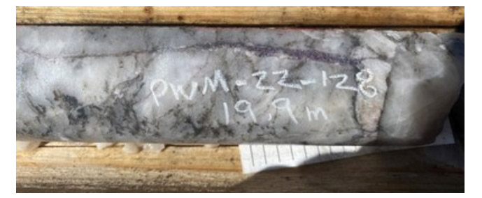
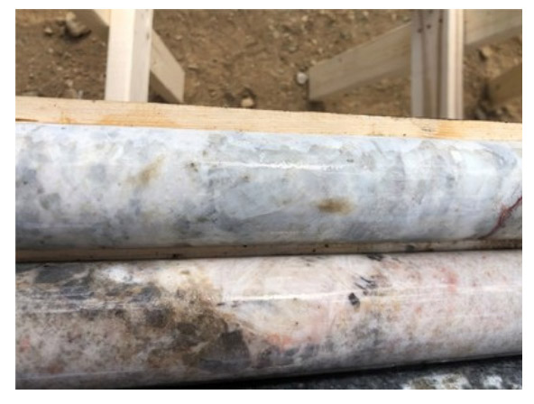
Purple lepidolite (Li) vein at 19.9 m, PWM-22-128, West Joe Dyke (CNW Group/POWER METALS CORP)
Figure 1 Purple lepidolite (Li) vein at 19.9 m, PWM-22-128, West Joe Dyke
White spodumene at 55 m in the top row and white coarse-grained cleavelandite in the second row, PWM-22-130, West Joe Dyke (CNW Group/POWER METALS CORP)
Figure 2 White spodumene at 55 m in the top row and white coarse-grained cleavelandite in the second row, PWM-22-130, West Joe Dyke
Main Dyke drill holes PWM-22-132 to135 intersected wide zones of spodumene pegmatite on the Main Dyke:
Visual mineral estimates of spodumene content does not necessarily indicate Li2O % grade in assays. Drill core samples from PWM-22-132 have been cut and submitted to SGS Cochrane lab for preparation and assay. Assays are pending and will be disclosed once received.
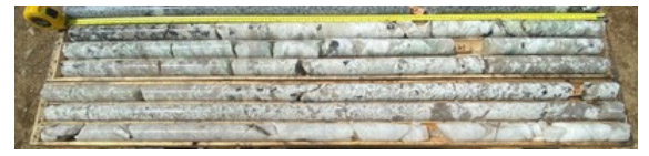
Abundant green spodumene in top core box and white and green spodumene in bottom box, last row is quartz core with coarse-grained spodumene, boxes 5 and 6, 20-29 m, PWM-22-134, Main Dyke. (CNW Group/POWER METALS CORP)
Figure 3 Abundant green spodumene in top core box and white and green spodumene in bottom box, last row is quartz core with coarse-grained spodumene, boxes 5 and 6, 20-29 m, PWM-22-134, Main Dyke.
Drill holes PWM-22-132 to 135 also intersected the new spodumene dyke below the Main Dyke: